Cevedale, 5-10 August 2024
This summer we went back to the Alps for the first time in 4 years. We were a big group, everyone had their own constraints and we only managed a short trip, 6 days. We also spent some time in the mountains before and after the trip. The trip was quite intense, and despite the small number of walking days, we didn't feel it was too short.
Coloured lines show our track. The arrow shows direction of travel, and the "P" icon shows the car park.
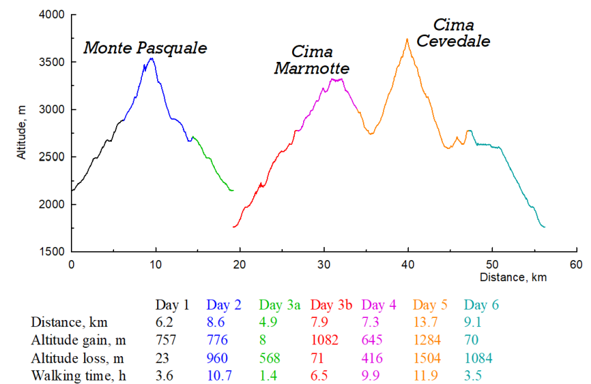
Walking time includes short breaks and lunch break.
General comments
- Cevedale massif. We missed the Alps and were very much looking forward to the trip. Cevedale did not disappoint. Sharp ridges, glaciers, lakes. Unfortunately, we were not able to complete the planned route on the second day. We got to high altitude (3500m) with almost no acclimatisation and so we were moving too slowly. On the second day, we planned to climb Monte Cevedale and descend on the other side. We climbed onto the ridge just above Colle del Pasquale. The descent to the pass was passable, but it would have taken some time. After that we would have had to climb to the top of Monte Cevedale, then it would have been quite a long descent down an easy wet glacier. It seemed we still had enough time, but we were moving very slowly, and thunderstorms were forecast for the evening. We decided not to risk it and to go back down and drive up to the other side of the ridge. With good acclimatisation in the middle of the trip we would have been able to make this route. We knew from the outset that going above 3500m on the second day was not the right thing to do, but it was the most logical route under our circumstances and we decided to give it a go. Despite having to return to the car park on the third day, we really enjoyed the route.
- Difficulty level. It was an interesting trip! We climbed several ridges (we even fixed the rope in one place for protection). The glaciers were very nice and easy to walk on. On the fourth day we almost got to Cima Venezia, but it was getting late, we still had to go back and descend a glacier. We came to a sloping slab which required setting up belay and decided not to go any further.
- Weather. We were very lucky with the weather. It was warm with very little rain: just a small thunderstorm in the evening of the second day and a couple of hours of light rain on the third day.
- Maps, paths and trip reports. We had a paper map, but mostly used the electronic map (OpenTopoMap). There popular routes are well-described on the internet, but it was hard to find any information on rarely-visited places. The popular paths were well marked, but where there were no information, there were generally no paths.
- People and animals. Cevedale is in a national park, and we did our best to camp away from refuges and popular paths. We only met a few other hikers. One of our camps was visited by a fox.
- Mobile coverage (e.g., for checking weather forecast) was good on almost all ridges and passes.
- Weather forecast. We used MeteoBlue.
Click the "Next" button to see the trip report and the pictures.


