Sarek National Park, 13 - 20 August 2022
This is the first time we are updating our website since the beginning of the "special military operation" in Ukraine. It's not that we didn't travel in 2022 but we felt too depressed to work on the website. Almost a year has passed, and we thought time has come to start uploading our trip reports again. The 2022 Summer Trip was in Sarek National Park in the north of Sweden. We started thinking about it a few years ago, and now with Yasha living in the north of Sweden, organising a trip to Sarek this year was no brainer.
The coloured lines show our track. The arrow shows direction of travel, and the "P" icon shows the car park.
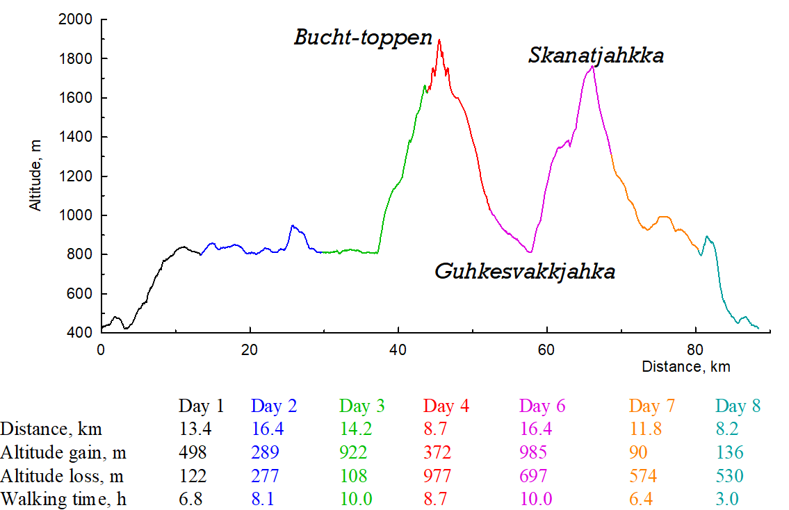
Walking time includes breaks and lunch.
General observations
- Our route. We love nordic nature and Sarek lived up to our expectations in full. It's one of the most remote places in Europe. Amazing tundra, reindeer, white mountains, glaciers... The approach to the mountains is rather long, there are very few paths in the area. There are virtually no bridges across the rivers. We were worried about river crossing but had no problems getting across the streams. One has to be mindful of flooded rivers in low-lying valleys. For instance the Guhkesvágge valley got badly flooded after a thunderstorm. Apparently, flood plains are shown with brown colour on the Lantmäteriet map. Our original plan was to cross the Mihkajiegŋa glacier and get to the Várdasjiegŋa glacier, but bad weather forced us to change our plans and get down by the Oarjep Sarekjiegŋa glacier. This gave us time to visit Skanátjåhkkå and enjoy the great views of the surrounding mountain ridges. In principle, there are enough glaciers in the National Park for much more technical trips but one has to be prepared to wait for the bad weather to pass. The Bucht-toppen - Stortoppen ridge would be amazing in good weather, and technically just right for us. Unfortunately, we only made it to Bucht-toppen and had to turn back because of the rain and poor visibility.
- Technical difficulties. There were virtually none. We did rope up on wet glaciers but they were not crevassed. We fixed two ropes for descending from Bucht-toppen, but in good weather they probably wouldn't have been needed.
- Weather. Overall, we got quite lucky with the weather but unfortunately the only spell of bad weather hit us on the key section of our route. We had to change our plans. We did have some extra days for emergencies but we did not fancy spending two days on a pass in strong wind and incessant rain without leaving our tents, so we went down.
- Maps, paths and descriptions. The Lantmäteriet map is sufficient for planning although we also had a paper map. There are very few descriptions of glacier trips on the internet. This is a desription of Sarektjåkkå and the Bucht-toppen - Stortoppen ridge (the same description with images is here). There are trip reports in Russian, from 2018 and 2017.
- People and animals. We met quite a few people down in the valleys but there was nobody on the glaciers. We saw many reindeer, they would get reasonably close to us - amazing animals!
- Mobile reception was unexpectedly reasonably good, we occasionally had a signal, particularly higher up, so we could check the weather forecast. We expected no mobile reception at all and carried a satellite phone.
- Webcam of Kebnekaise mountain is here.
Click the Next button for trip report and pictures.


